
Metalogue on the Value of Cultural Mapping
Published: Kerb 28 - 2020
Author: Greg Grabasch, Barbara Bynder
When I looked at the map that you fullas were doing it was historical for me cos I never thought it would be like that and I had no concept of cultural mapping but once I saw it, it was really historical and I was watching the people that were coming in to look at it and they were looking really impressed because youse were contextualising our history and we could see it.
Farley Garlett, Noongar Elder
Introduction
This paper briefly explores the value of cultural mapping within the built environment through the methodology and method of metalogue.
Metalogue is a qualitative research methodology that allows for public discussion between researcher and participant to be recorded as scientific data (Staller 2007). Bateson (2015) termed the process metalanguage. In this paper metalogue connects the concept of ‘yarning’ in Noongar culture as an Indigenous methodological approach to research and provides a sense of respectful collaboration between Indigenous and non-Indigenous participants.
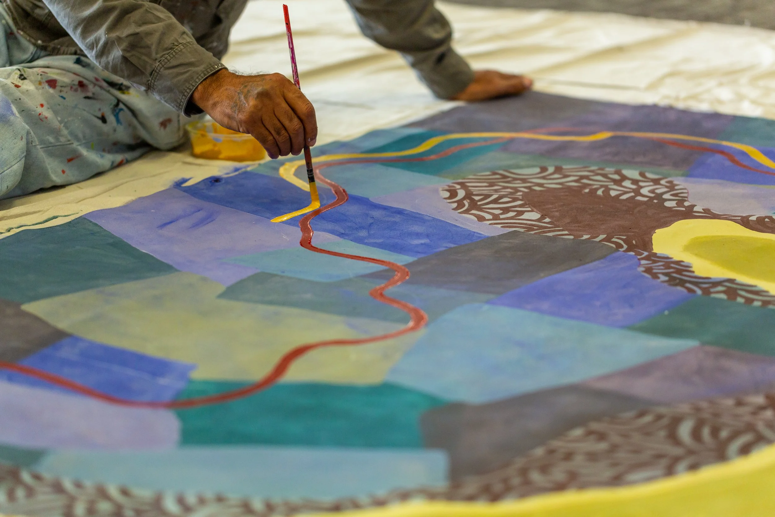
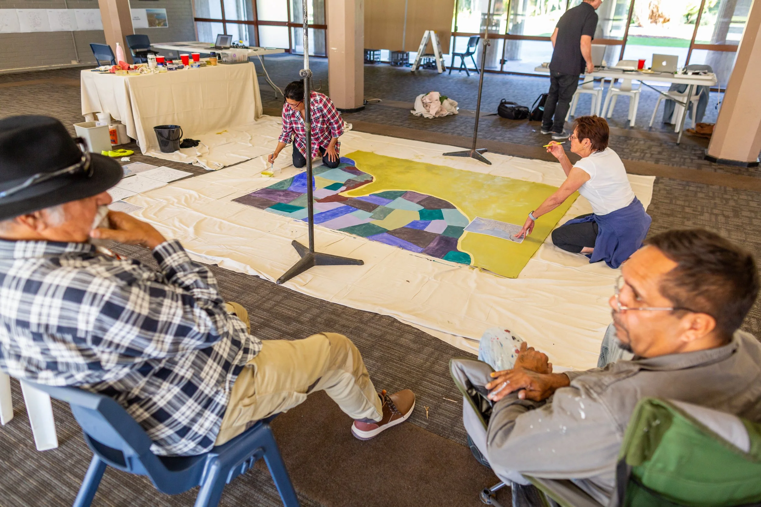
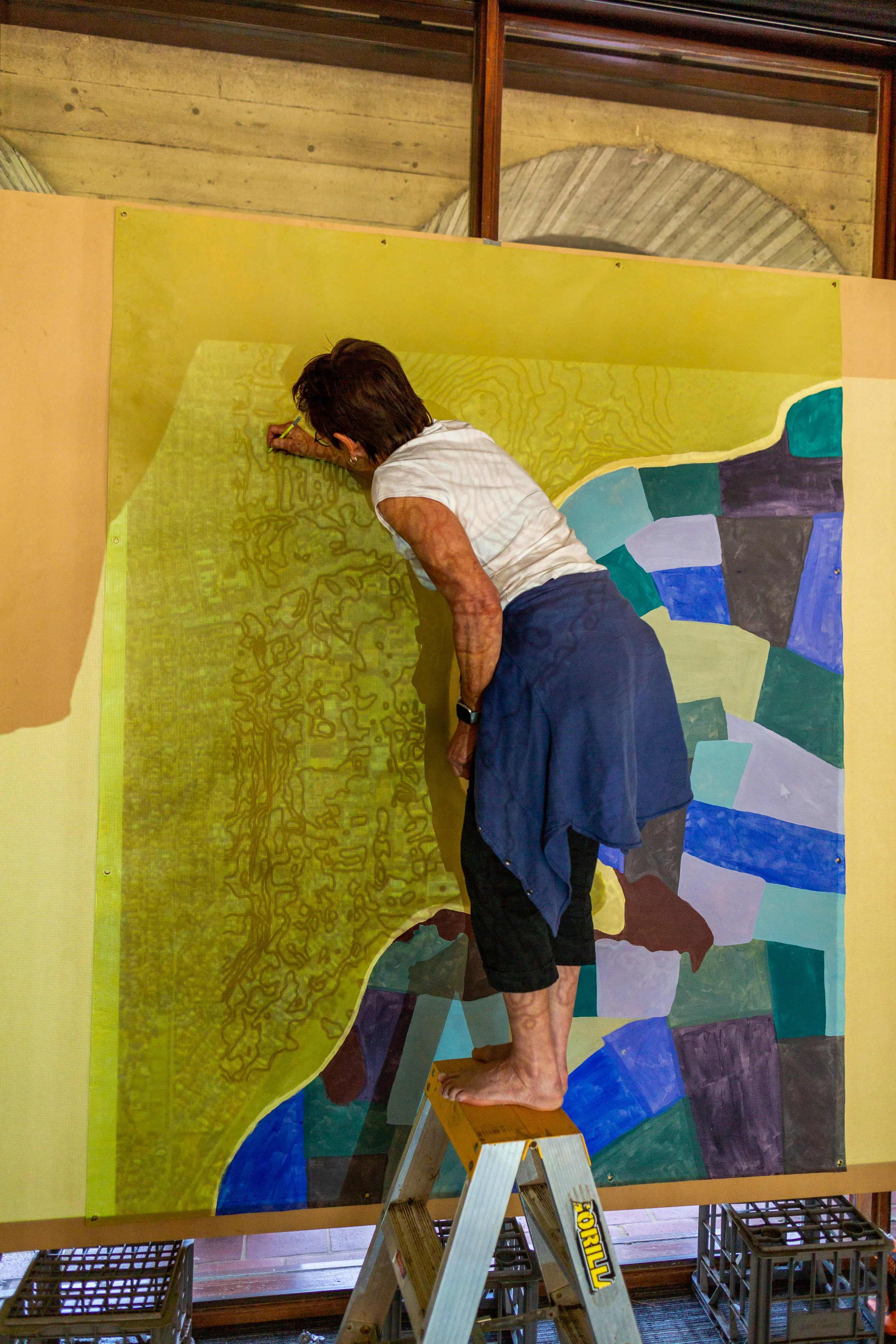
Cultural mapping recently provided planning direction for the University of Western Australia (UWA) Crawley Estate Masterplan, Perth, Western Australia. The master planning is to guide contextualization of the University’s mission statement: To provide world-class education, research and community engagement for the advancement of the prosperity and welfare of our communities. The cultural mapping outcome was a 2.5 x 2.5-metre acrylic painting on stretched canvas. The painting essentially depicted a collection of orated yarning and storied discussions providing key themes, distinct locations, broader areas and lines of cultural significance. This information was located on a pencilled scaled base that included topographical contours, landscape features and the estates cadastral boundary. As part of the mapping process parts of this pencilled base were edited, lined in, removed or adjusted for the cultural mapping story to be told.
Barbara Bynder and Greg Grabasch discuss the benefits of cultural mapping and how it may provide a canvas for new design conversations in the following metalogue.
Images: Jason Thomas
Cultural Mapping
Greg:
Cultural mapping continues to be an essential planning and design element for a recent large estate master planning process where tangible and intangible values of place were realised and documented in a non-conventional way.
Barb:
For me, cultural mapping realized the concept of art as ‘living language’ and also presents the methodology of art as reflective practice where tangible and intangible values of place became visually recognizable.
Cultural Mapping reflects on the past and sometimes challenges ones thinking whilst bringing the past into the present to dialogue with historical and living accounts of cultural knowledge of a specific area.
Our Project
Greg:
The stories and place narratives were respectfully provided by Noongar Elders and Leaders who have the authority to speak for this area. Much of the knowledge relate directly or was similarly connected to the estate's wider context.
Two Noongar artists Barbara Bynder and Shane Hansen were guided by Noongar Elders standing and sitting around the painting, pointing and giving strong direction on how and where to include the appropriate information. As a first opportunity to culturally map within an urban environment, Kim Mahood artist and writer, facilitated the process.
Barb:
The cultural mapping project was about projecting a visual cultural map of the area that recognised Noongar cultural values within the built environment. I have to say as a researcher and as an artist I learnt a lot from the Elders and from Kim Mahood. It was a privilege to be guided by my Elders in the cultural way and to be guided by Kim, an experienced cultural mapping strategist. Kim and I had many conversations in relation to art versus map and I found myself reflecting on my own thinking about art as living language and the concept of communication through visual art as well as gain deeper understanding of the idea of cultural mapping. It was inspiring to be able to apply theory to practice.
What is Cultural Mapping?
Greg:
Kim Mahood (2005) in her article ‘Mapping Outside the Square’ explained:
‘The project's intention was to bring together scientific and Aboriginal knowledge of the Lake Gregory area, to record traditional stories and oral histories, to make photographic and video documentation of campsites, archaeological and geological sites, bush food and bush medicine, and to record place and family names.
The central template for this recording process was a large canvas painted map, on which was inscribed dreaming tracks, place names, soakwaters and campsites, the precise areas to which people's ancestors held entitlement, and the locations where large groups of people came together during the period of first encounters between white settlers, missionaries and Aboriginal people.
The revisiting of locations and camping out on country provided an opportunity for elders to pool their knowledge of names, places and events at risk of being forgotten, for the purposes of educating their children in their country and their culture. The inclusion of non-Aboriginal information was an incremental shift towards bridging the gap between knowledge systems, and an attempt to provide a basis for future planning of the management of the lake.’
For me Cultural Mapping offers an authentic reciprocal approach where values are embedded within a multispecies - land relationship, the learning, caring for and maintaining these interrelated systems, which is in great contrast to the consumer - development approach, where values reside in human centred ownership and control of land.
Barb:
Cultural mapping is a communication tool that speaks to all who participate in and view the process in such a way as to convey specific information relational with the site location, the built environment and its surrounds. Indigenous knowledge and values are embedded within the map demonstrating connection to country that is ongoing today.
During conversations with Kim about cultural mapping, there was a sense of difference to mapping in remote areas as opposed to mapping the built environment, however the outcome was exciting, innovative and inspirational.
Approach
Greg:
Cultural mapping is as much a process as a pragmatic event. A process by which words and thoughts manifest shape and meaning on canvas. Where cadastral plans commonly used for quantifying ownership and control are transformed to reveal insight into a living connected entity, rich with embedded meaning and purpose.
Non-Indigenous people often approach collaborative projects with Aboriginal and Torres Strait Islanders believing they have not much to offer and struggle with their own settler colonial histories. The cultural mapping approach inquires participants to examine anew the meaning of place in a participatory way, and together realize their relationship and responsibility to land. Cultural mapping provides opportunity for art, science and traditional knowledge systems to come together, to reveal and re-imagine a contemporary path for living in Australia.
Barb:
The approach was collaborative from beginning to end, hence producing a powerful imagery that speaks from a layered historical perspective and presents opportunity for understanding our shared history whilst acknowledging and contextualizing the past and the present with the idea of modernity. Cultural mapping aims to reimagine and contextualize cultural knowledge upon modern landscapes, acknowledge our shared history through story and gain understanding of change, adaptation and evolution of culture within society (Malinowski 1944).
Learnings
Greg:
We found cultural mapping often aligned with the areas ecological and seasonal patterns, with landscape form, open and hidden paleo water bodies and the sky. The realization of a way of becoming, having a relationship with land, with an interconnected entity, in which Aboriginal People continue to ceremonially observe, access, traverse and manage.
It was evident that was is being shared is more than a physical or emotional expression. Similarly, I and others including Deborah Rose and Thom Van Dooren in their discussion on Storied-places for multispecies (Rose and Dooran 2012, 2) observe that when Aboriginal people have the opportunity to ‘sing’ or ‘yarn country’, there is a renewal of a bond, a spiritual connection a sense that only comes when one is communing with an old friend. A mutual benefit results, where the health of the land becomes entwined with the health of its Custodians. This understanding between the landscape and the Australian Aboriginal could be understood as having formed over eons of time and derived from a deep knowledge of ‘place’ and its complex systems, a fluid mutualistic understanding of people moving with the rhythms of their country. The meaning for ‘place’ in this discussion not comprise an enclosed box, separated from the world, but instead, ‘place’, ‘is made up of multiple paths of entanglement’, and … ‘these places are formed through movement, seen as stations in life, and most importantly, requiring the comings and goings of people’ (Ingold 2008, 1809). Therefore ‘place’ cannot be separated from the interrelated relationship between land and people.
Barb:
The Noongar Six Seasons governs Noongar culture on a broad level, providing guidance in the cultural way and teaching us about environmental and seasonal patterns that is entwined with past, present and future modes of knowledge and understanding of the urban landscape from an Aboriginal perspective. In terms of place making and meaning, Noongar history and the idea of place making is represented within the narrative through story which embeds Aboriginal philosophy into the built environment signifying deep knowledge and meaning of ‘place’ within the modern context.
Conclusion
Greg:
The philosophical foundation of cultural mapping is based on the understanding that the health of people and all species is central to the health of their environment, and vice versa. The integrity of our environment, our land relies on society’s education and awareness of this symbiotic relationship; also known by landscape practitioners as ‘Valued Landscapes’, or, as Australian Aboriginal and Torres Strait Islander people recognise as being, ‘Connected to Country’. In contrast, a populace disconnected from, or in a limited relationship with, their environment tends to polarise between distant unmanaged conservation or unsustainable abuse.
Barb:
Cultural mapping has the potential to educate, learn from and pass on knowledge of the tangible and intangible elements of culture and the environment in which we live. The concept of connection to country and understanding that the health of people is central to the environment is not always visible within an urban landscape and has the potential to remain an idea, however when you view these elements visually within the cultural map, we can change the way we think about the land because we see that the area is made up of physical, emotional and spiritual connections to country that become tangible therefore is more than an idea.